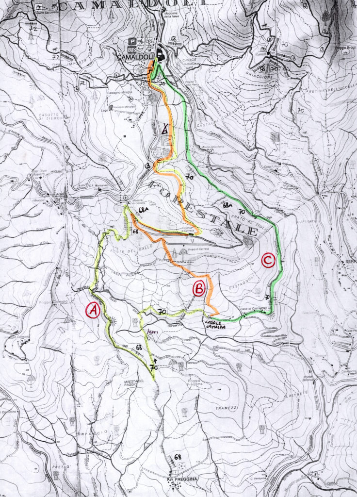


THREE ITINERARIES suitable for all to reach Camaldoli Monastery on foot and how to reach the footpaths in the Foreste Casentinesi, Monte Falterona and Campigna National Park
ITINERARY A (yellow)
Uphill: mt. 224
Downhill: mt. 86
Distance and time: 5,850 km – 2,15 h.
From Casale Camalda (678 m), take the track leading to the left at the children facilities in the yard. The track follows a path (CAI n° 68/a) marked with red and white markings you’ll see on trees and stones and it is also the initial section of the Camalda Path.
 The first section is easy walking, almost on the flat; after passing meadows, fruit trees and reforestation with Austrian pines, you enter a wonderful wood of hardwood trees, mainly bitteroaks with some maples (opalo, field maples and alders), black hornbeams, chestnut trees, Douglas firs and other species.
Turn down to the left at the first fork and continue following the red and white signs marking the path. After you have forded the Barberine stream, the path starts to climb amidst brambles and wild strawberries with woods of silver firs on the left.
When you arrive at the ruins of the old farm called “I Prati” (703 m) it is possible to take a small sidetrack to the left of the house (downhill) in order to reach a large clearing where you may be lucky enough to see wild animals grazing if you approach in silence (deer, roe deer, fallow deer and wild boar) especially in the early hours of the morning and at dusk.
After passing the “I Prati” ruins, the path climbs up to the Frèggina pass (745 m) and then starts to descend between fenced fields on the left and reforestations of Scots pines and Austrian pines on the right. After about 300 m you should take the path that takes a sharp right turn (CAI n° 68); if you carry straight on, you will arrive at Frèggina village. The path is now marked more often with CAI markings and you soon go past some panoramic viewpoints across the Barberine valley, Casale Camalda’s land and woods and Serravalle village. After the Fonte del Gallo spring (775 m), you climb up to Maestà di Cerreta (902 m), a picnic spot with tables and benches. Make sure you don’t take the tarmac road that starts there but turn right onto the wide path: you’ll find this is also marked with wooden signs for “Prato al Tiglio” and “Camaldoli” (the latter is often removed and therefore missing). After a couple of hundred metres you will arrive at the old Summer Holiday Camp at Cerreta (877 m), which is no longer used and is fenced off. Continue for about 50 metres and take a small path uphill to the left that indicates the way for “Camaldoli” with a wooden sign. There are other similar signs to guide you to the last path downhill (keep to the right at the next fork in the path) and this will take you to the Monastery, through lovely woods with beech, chestnut and other species of trees. The experts among you may notice clear signs of the old charcoal pits that can still occasionally be seen.
Follow the many wood signs for “Camaldoli” on the last stretch near the campsite fence and you will pass through a superb, centuries-old wood of chestnut trees shortly after this, finally reaching Camaldoli Monastery (816 m). The visit to the Monastery is very interesting and takes in the church, two cloisters, the guest lodge, the bookshop (that sells on a fair-trading basis) and the old pharmacy. Should you wish to continue up to the Hermitage (1111 m), simply follow the well-marked path and calculate about 45 minutes –one hour. Follow our itinerary B (orange) or C (green) for the return route. (To return with route C, take CAI path n° 68/a starting out on the side of the car park, almost in front of the hotel-restaurants, marked with red and white signs. The return route with itinerary B coincides with itinerary A as far as Cerreta, but is simply taken backwards).
 The path continues uphill, past bushes and shrubs of gorse, dog roses and juniper. Continue to follow signs similar to the first one until you arrive at a ridge with a wonderful view that takes in the Pratomagno Massif and Catenaia Alp. Continue on through copses of bitteroaks and downy oaks, woods of Austrian pine and formations of Douglas firs until you enter a wood of tall bitteroaks, with the occasional chestnut, silver fir, Douglas fir and other hardwood trees. Make sure you keep to the right and go uphill at the last fork and the path will take you straight to the Cerreta seedling nursery (858m). The path now becomes a forestry road and as you walk along it you will go past majestic examples of Douglas fir and crabwood cedars, as far as Maestà di Cerreta (902 m), a picnic spot with tables and benches.
 The experts among you may notice clear signs that can still occasionally be seen of the old charcoal pits Follow the many wooden signs for “Camaldoli” on the last stretch near the campsite fence and you pass through a superb centuries-old wood of chestnut trees shortly after this, finally reaching Camaldoli Monastery (816 m). The visit to the Monastery is very interesting and takes in the church, two cloisters, the guest lodge, the bookshop (that sells on a fair-trading basis) and the old pharmacy. Should you wish to continue up to the Hermitage (1111 m) simply follow the well-marked path and calculate about 45 minutes –one hour.
 The scenery changes after you take a sharp left: a wood of large, centuries old chestnut trees starts here, once cared for by the monks of Camaldoli. Continue west, along the flat path amidst these large chestnut trees until you arrive at the gravel road at Prato al Tiglio (724m). Take this road uphill to the left for about 350 metres, and then continue gently downhill. You will come across a sports ground and then a ford that has become a little trickier because of a landslide, and then, after about 1.5 km, you will find yourself directly below the enormous Camaldoli Monastery (816m). The visit to the Monastery is very interesting and takes in the church, two cloisters, the guest lodge, the bookshop (that sells on a fair-trading basis) and the old pharmacy.
 lShould you wish to continue up to the Hermitage (1111 m) simply follow the well-marked path and calculate about 45 minutes –one hour.